Maritime Search and Object Detection | Wide Area Maritime Search | Overwatch Imaging
top of page
Overwatch Imaging, wide-area maritime search, Wide-area search, Wide-area imaging, Wide area motion imagery, Sensor enhanced fire recon, Sensor enhanced, Airborne ISS, Airborne imaging, Airborne imaging, Multispectral payload, Aerial mapping , Multispectral imaging, Multispectral mapping , Fire mapping, Wildfire mapping, Fire terrain mapping, NIROPS, Integration , Autonomous image processing, Aerial ISR, Airborne search and rescue, Maritime search and rescue, Maritime ISR, Coastal surveillance system, Vision systems, Remote sensing, edge computing, AI enabled, Artificial intelligence, Geospatial, Cross-cueing, Wide area scanning, Situational awareness, Computer vision, Dual-asix, NADIR, Step-stare , Payload , Smart sensor, Cursor on target, Collaborative AI, Distributed Sensing, Agile combat deployment, Personnel recovery Sensor-to-sensor, Unmanned aircraft, Uncrewed systems, UAV, UAS , Disaster response, Unmanned systems, Infrastructure inspection, Linear asset inspection

MARITIME ISR

Automated Search, Detection, and ISR Sensors
and Software for Maritime Domain Awareness

Leveraging advanced AI detection algorithms and high-resolution data collection methods, Overwatch Imaging sensors and software provide unparalleled monitoring of maritime environments. From detecting potential threats and correlating AIS signals, to aiding in search and rescue missions, our solutions deliver precise, actionable intelligence that empower maritime domain operations with next-generation intelligence and unmatched situational awareness. 

  • Passive image-based optical radar

  • Detect ships at ranges of 15+NM

  • AIS DATA integration via interactive UI

  • Easily target precise search areas 

  • Low bandwidth data requirements 

  • Thermal sensors allow day/night operation

Maritime ISR with Overwatch Sensors 

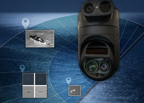
Overwatch Imaging smart sensors are optimized for automated, wide-area search, object detection, and rapid intelligence analysis and delivery.  

Maritime ISR with 3rd Party Gimbals

Automated Sensor Operator (ASO) leverages Overwatch Imaging's robust software architecture to add powerful search and detection automation to FMV Gimbals 

SEARCH SMARTER

Advanced AI capabilities automate focus-intensive maritime search, object detection, and ISR tasks

Overwatch AI

Overwatch AI neural net algorithms are trained to detect a wide variety of objects in sensor data feeds, including difficult to spot ships-at-sea of various dimensions. This enables operators and decision makers to scan vast areas autonomously, detect and interrogate multiple objects of interest simultaneously, and maintain a continual view of the scene ahead.
 
Sensor control, image collection, and data analysis are executed by software, allowing operators to maintain heads-up situational awareness while they review intelligence and interact with the system through an intuitive user interface or compatible MMS. 

Overwatch Imaging, wide-area maritime search, Wide-area search, Wide-area imaging, Wide area motion imagery, Sensor enhanced fire recon, Sensor enhanced, Airborne ISS, Airborne imaging, Airborne imaging, Multispectral payload, Aerial mapping , Multispectral imaging, Multispectral mapping , Fire mapping, Wildfire mapping, Fire terrain mapping, NIROPS, Integration , Autonomous image processing, Aerial ISR, Airborne search and rescue, Maritime search and rescue, Maritime ISR, Coastal surveillance system, Vision systems, Remote sensing, edge computing, AI enabled, Artificial intelligence, Geospatial, Cross-cueing, Wide area scanning, Situational awareness, Computer vision, Dual-asix, NADIR, Step-stare , Payload , Smart sensor, Cursor on target, Collaborative AI, Distributed Sensing, Agile combat deployment, Personnel recovery Sensor-to-sensor, Unmanned aircraft, Uncrewed systems, UAV, UAS , Disaster response, Unmanned systems, Infrastructure inspection, Linear asset inspection

SEARCH

Scan wide areas of interest while Overwatch software controls sensor operation and analyzes image data in real-time. 

Overwatch Imaging, wide-area maritime search, Wide-area search, Wide-area imaging, Wide area motion imagery, Sensor enhanced fire recon, Sensor enhanced, Airborne ISS, Airborne imaging, Airborne imaging, Multispectral payload, Aerial mapping , Multispectral imaging, Multispectral mapping , Fire mapping, Wildfire mapping, Fire terrain mapping, NIROPS, Integration , Autonomous image processing, Aerial ISR, Airborne search and rescue, Maritime search and rescue, Maritime ISR, Coastal surveillance system, Vision systems, Remote sensing, edge computing, AI enabled, Artificial intelligence, Geospatial, Cross-cueing, Wide area scanning, Situational awareness, Computer vision, Dual-asix, NADIR, Step-stare , Payload , Smart sensor, Cursor on target, Collaborative AI, Distributed Sensing, Agile combat deployment, Personnel recovery Sensor-to-sensor, Unmanned aircraft, Uncrewed systems, UAV, UAS , Disaster response, Unmanned systems, Infrastructure inspection, Linear asset inspection

IDENTIFY

Operators review detections via an interactive user interface, where they can view full-res imagery, AIS info, GIS coordinates and more.

Overwatch Imaging, wide-area maritime search, Wide-area search, Wide-area imaging, Wide area motion imagery, Sensor enhanced fire recon, Sensor enhanced, Airborne ISS, Airborne imaging, Airborne imaging, Multispectral payload, Aerial mapping , Multispectral imaging, Multispectral mapping , Fire mapping, Wildfire mapping, Fire terrain mapping, NIROPS, Integration , Autonomous image processing, Aerial ISR, Airborne search and rescue, Maritime search and rescue, Maritime ISR, Coastal surveillance system, Vision systems, Remote sensing, edge computing, AI enabled, Artificial intelligence, Geospatial, Cross-cueing, Wide area scanning, Situational awareness, Computer vision, Dual-asix, NADIR, Step-stare , Payload , Smart sensor, Cursor on target, Collaborative AI, Distributed Sensing, Agile combat deployment, Personnel recovery Sensor-to-sensor, Unmanned aircraft, Uncrewed systems, UAV, UAS , Disaster response, Unmanned systems, Infrastructure inspection, Linear asset inspection

DETECT

Image data is analyzed by AI algorithms to detect and display user-defined objects of interest from the continual data feed. 

Overwatch Imaging, wide-area maritime search, Wide-area search, Wide-area imaging, Wide area motion imagery, Sensor enhanced fire recon, Sensor enhanced, Airborne ISS, Airborne imaging, Airborne imaging, Multispectral payload, Aerial mapping , Multispectral imaging, Multispectral mapping , Fire mapping, Wildfire mapping, Fire terrain mapping, NIROPS, Integration , Autonomous image processing, Aerial ISR, Airborne search and rescue, Maritime search and rescue, Maritime ISR, Coastal surveillance system, Vision systems, Remote sensing, edge computing, AI enabled, Artificial intelligence, Geospatial, Cross-cueing, Wide area scanning, Situational awareness, Computer vision, Dual-asix, NADIR, Step-stare , Payload , Smart sensor, Cursor on target, Collaborative AI, Distributed Sensing, Agile combat deployment, Personnel recovery Sensor-to-sensor, Unmanned aircraft, Uncrewed systems, UAV, UAS , Disaster response, Unmanned systems, Infrastructure inspection, Linear asset inspection

INTERROGATE

Cross-cue FMV gimbal or networked payload with precise GIS coordinates sent via standard Cursor on Target messaging.

Overwatch Imaging, wide-area maritime search, Wide-area search, Wide-area imaging, Wide area motion imagery, Sensor enhanced fire recon, Sensor enhanced, Airborne ISS, Airborne imaging, Airborne imaging, Multispectral payload, Aerial mapping , Multispectral imaging, Multispectral mapping , Fire mapping, Wildfire mapping, Fire terrain mapping, NIROPS, Integration , Autonomous image processing, Aerial ISR, Airborne search and rescue, Maritime search and rescue, Maritime ISR, Coastal surveillance system, Vision systems, Remote sensing, edge computing, AI enabled, Artificial intelligence, Geospatial, Cross-cueing, Wide area scanning, Situational awareness, Computer vision, Dual-asix, NADIR, Step-stare , Payload , Smart sensor, Cursor on target, Collaborative AI, Distributed Sensing, Agile combat deployment, Personnel recovery Sensor-to-sensor, Unmanned aircraft, Uncrewed systems, UAV, UAS , Disaster response, Unmanned systems, Infrastructure inspection, Linear asset inspection

AIS

DATA
INTEGRATION

Review AIS signal data in Overwatch UI

A critical feature of Overwatch Imaging's Maritime Intelligence software is the ability to view AIS signal data in real-time on the interactive user interface. This empowers operators with several key capabilities, including cross-reverencing visual detections with signal data, interrogating all signals in a search area, and investigating vessels for AIS spoofing. 

Key Features

bottom of page